We used these survey instructions during our 2018-2022 data collection. This page has been archived for the historical record.
Waterbirds can be hard to obtain good winter information about because they move around a lot and because surveying waterbodies often requires a different approach to other habitats. Consequently, we plan to conduct supplemental surveys of lakes and ponds. Because of the way that birds use these sites, we will focus on the waterbody as the area over which species should be counted, with a goal of counting all individuals using the waterbody, regardless of where block boundaries lie.
Protocol
- Pick a lake or pond in your block and identify a point that will allow you to see as much of the site as possible.
- For larger lakes, it is OK to move between multiple survey points to ensure that you can see all parts of the lake. If you do move, however, be careful to pay attention to where birds are, so that they do not get double-counted if seen from different locations. For the state’s largest lakes, attempting to get complete surveys may be impractical, in which case, use the methods described for shoreline surveys of the coast and major rivers.
- Record the latitude and longitude of the center of the waterbody (note that this may not be exactly where you observe the birds from) and give the waterbody a name.
Instructions on how to provide location information are here. - Visit as frequently as you are able (ideally at least every two weeks, but even 1-2 visits are valuable) and count all waterbirds and birds of prey using the site. Frequent surveys will allow us to understand how use of these habitats changes over the course of the winter.
- There is no fixed period of time for these surveys – simply spend whatever time it takes to count all birds on the waterbody. For many of the state’s ponds and small lakes, that might just be a few minutes, but be sure to record the start and end time of each survey.
- Counts should include all geese, swans, ducks, grebes, coots, shorebirds, gulls, loons, cormorants, herons, and kingfishers.
- Because birds of prey are sometimes drawn to waterbodies to hunt, we ask that you also record any osprey, eagles, hawks, harriers, falcons, or owls seen during your survey. Reporting other species is optional.
- Record your best estimate of the percent of the waterbody that is covered by ice.
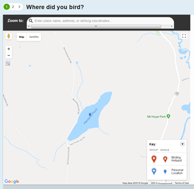
- Data can be submitted as an eBird checklist using the center of the waterbody as the location point (see example image below); please write “CT Bird Atlas waterbody survey” in the comments box and share with the ctbirdatlas account (for instructions on how to do this, go here). Alternatively, data can be submitted on the form here, again providing the latitude and longitude for the center of the waterbody.
Locating a survey marker: When entering a site location for a waterbody, simply place the location marker (blue pin) in the center of the waterbody, as shown for Hansens Pond in the image from eBird, below. If you are submitting data using the paper form, you can use Google Earth on a phone or computer to select the point and then read off the coordinates (for an example see this page here).
